Thursday, December 24, 2015

Hung By The Chimney With Care


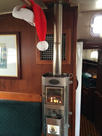
No stockings, but Santa's hat is hung by the chimney with care, hoping to dry out in time for the overnight deliveries.


And by the way, notice that the glass in the Dickenson is nice and clear - for a nominal price I replaced the old one.  It had become a little cloudy and frosted over the decades, I assume by the reaction between ash, glass and high temperatures.


Merry Christmas to all!  May visions of AIS transponders, chart plotters and new sails dance in your heads!


Monday, December 21, 2015

Peace On Earth


Peace on Earth.

And on the docks.  Please.

Novembers and Decembers are normally stormy months here in the PNW, but this year has taken it to extremes.  We have been blasted by one major storm after another since the beginning of November.  We are all getting weary of the wind and rain - I am pretty confident that I am speaking for everyone on the docks with this.

Ah, but today is the day I have been looking forward to since that first November freeze:  the winter solstice (technically, at 8:49 PM)!  From this day forward, until all reckoning is lost in those warm golden hazy days of June, each day will be a little longer.

And the sun will ride a little higher in the sky every day.  In fact, this time of year, the sun is so low that much of the day is lit by that reddish orange cast that normally only comes with sunrise and sunset.  This preys on the soul.

So today we are looking forward to the beginning of the new set of seasons, to the end of the terrible storms, to the lengthening of the day.  To peaceful sails under warm 15 kt breezes and sundowners in calm anchorages.

Today starts the journey to Summer!

Monday, December 14, 2015

It's About Time

I can't believe that so much time has slipped by.

Needing to do some straightening and cleaning out, I delved into the dark recesses of our storage shed and found...  No, you probably didn't guess it.  Eolian's old bowsprit.  The one I removed in 2008, seven years ago.  SEVEN YEARS!

So, how do you dispose of a 10 foot long piece of partly rotten mahogany?

A symbolic act

Exactly.  You chainsaw it up into two foot long pieces, stack it up and burn it.  Stuffed in the bottom of the pile there you can also see the remains of the mizzen spreaders, which I also rebuilt, but just this last spring.  I really don't have a good explanation for why I kept the old bowsprit around so long.  But each time I looked at it over the years, I told myself, "I'll hang onto it a little longer, just in case."  Just in case what?  I have no idea - but somehow I felt that I was making a prudent decision to keep it a little longer.  No, I don't understand how my mind works either, but I have learned to live with it.

As it turns out, replacing the bowsprit couldn't have waited...  shouldn't have waited as long as it did.  When the saw dug into the last cut, two feet from the butt, a flurry of powder exploded out instead of chips.  There was not very much wood in there...

Not good

In fact, the rot had hollowed out the inside of the spar.  Frightening!  Despite this, there was very little evidence of the rot on the outside.  A sobering exposé for those whose boats have wooden spars (hopefully not made of mahogany, a terrible wood choice for outdoor service).

At this point, the only remaining unreplaced wooden spars on Eolian are the main spreaders, which I continue to inspect carefully every year, and to which I apply a fresh coat of paint as often as needed.  So far, there is no reason to replace them - they are as sound as when they were new.

Monday, December 7, 2015

No, It's Not That Simple

The tide comes in, the tide goes out. The current flows in, the current flows out. That's it, right?

Well, no, actually.


First a little orientation for those of you not familiar with the area - this image shows the upper left-hand part of Washington State.  The important features to note are:
  • The Strait of Juan de Fuca - the large strait connecting the Pacific Ocean to the entire Salish Sea
  • Puget Sound - the body of water reaching from a little north of Everett southward - basically everything south of the large word "Sea"
  • The San Juan Islands - the group of islands just north of the large word "Sea" and south of the border with Canada
  • The Strait of Georgia - the body of water running north of the San Juan Islands, between Vancouver Island and the Canadian mainland

So the water coming in via the Strait of Juan de Fuca (and it is a LOT of water - imagine how much has to flow thru here to raise the water level in all of Puget Sound and the Strait of Georgia 12-16 feet in just 6 hours...) meets a decision point when it reaches the eastern end of the strait...  it is forced to split, part going north into Canada, and part going south into Puget Sound.  That's a lot of momentum, forced to make a sharp turn in one direction or the other.  You might imagine that things could be a little, umm, confused at the eastern end of the Strait.  And you'd be right.

But like Ron Popeil says...  "Wait!  There's more!"  

Tho the water heading south to Puget Sound has a pretty straight shot past Point Wilson and into Admiralty Inlet, the northbound flow faces the obstruction of the San Juan Islands:


The image above shows a realistic picture of what the flows look like (the entrance to Admiralty Inlet and Puget Sound is at the bottom right-hand corner).  First, notice that two major gyres have developed, just south of Victoria and at the entrance to Admiralty Inlet, and some minor ones off of Port Angeles and at Cattle Pass just south of San Juan Island.  And the flow paths thru the San Juan Islands themselves are by no means simple.

But wait!  There's more!  

The picture gives the impression that things are static.  Reality isn't.  The flows morph and change throughout the entire tidal cycle, changing and reversing directions in the most amazing ways.  And the flows are different for each day in the tidal cycle, and for each month of the year.  In our area we have two tidal cycles that, like two wave trains on the ocean, some times nearly cancel each other out, and at others reinforce each other.  How could a mariner ever keep track of all of that?

Well there is an answer.  In 1999 the Canadian government compiled a series of nearly a hundred charts like the one above and published them in book form (the chart above is a portion of one of them):


But wait! There's more!

It's not easy to select the chart that applies to a particular date and hour.  I'm not going to go into how the published instructions in the book select the particular page you need.  Just know that it uses a couple of nomographs and is not simple.

Because of this, there are a couple of published tables (Washburne's, Murray's) that you just enter with a date and time and they tell you which page in the Current Atlas applies.  But tho the Current Atlas is timeless, these published tables need to be re-purchased each and every year.

But wait! There's more!


There is a solution to that too!  A sharp individual named Emanuel Borsboom puts equivalent tables online for you to view or download and print (free for non-commercial use).  If you are computer savvy, he also makes the code that produces the tables available.  With that code, you can produce your own tables forever, without depending on Internet access.  Or Borsboom's continued interest in publishing them online.

So, armed with this information the astute mariner should not get caught unintentionally stemming an adverse current. With flows approaching 5 kt in some places this is not unimportant, especially for sailors whose boat speeds mean that they could actually be moving backwards.

Our copy of the Current Atlas is on its way, and we are looking forward to speedier and more relaxed passages next season!  No surprises!


Update

The world has moved on in this Internet age - you must see this!


Tuesday, December 1, 2015

Salvage? Or...

All of us here in Puget Sound are aware that we've had some pretty tremendous wind storms lately, especially those of us who went days without power.  But the boaters among us are even more aware.  Whether your boat was tied to a dock, moored on a buoy, or (Heaven forbid) at anchor during these storms, there was a great risk of damage.  In the worst case, the boat would be torn loose from its moorings...

And that happened to this Riviera Star 24 (made by Progressive Plastics in Richmond BC) that washed up onto the launch ramp at Camano Island State Park.  

November 26

Apparently, adrift and driven by the high wind, the boat first ran into the finger dock and then jammed under it, keel first, where it spent some time, pounding on, and being pounded by the dock floats, as high wave after high wave passed thru.  It must have at some time been nearly completely horizontal, since there is sea grass high in the rigging as well as all over the deck.

I spoke to the Park Ranger and asked what the story was about this poor runaway...  He told me that they had been concerned about damage to their dock so they pulled the boat off and tied it as you see.  The Park rules do not allow overnight moorage on the dock, so just tying it to the dock was not an option.
 
November 27

Talking to the Ranger, I allowed as how the Park had acquired a boat thru salvage rights.  But no, he told me that their lawyer had advised him that the boat was still the property of the original owner, and that they had begun a legal notification process that would last at least 30 days.  Supposedly at the end of the notification period, they could legally declare the boat as derelict and then take possession of it.

November 30
As you can see from the progression of pictures, the boat is now full of water.  The interior is surely a ruin with all wood bulkheads and other items warped, the wiring is soaked in seawater and will need to be replaced.  In fact at this point the boat would be more valuable as a bare hull.  By the end of the notification process, after another month (at least) of pounding on the bottom, even the value of the hull will probably be lost.

December 7

So... Has the park received good legal guidance, treating this boat exactly as if it were an abandoned automobile under land-based law?  Doesn't a boat adrift constitute salvage under Admiralty law?  I do know that when a friend of ours lost his engine, grounded on the rocks and called for a tow, his boat was declared salvage and became the property of the towing company (he eventually bought it back via the normal procedures).

How is this situation different?